Electromagnetics (electrical conductivity and magnetic susceptibility)
Electromagnetic methods are capable of measuring either the electrical conductivity or magnetic susceptibility of soils (or, with newer EM systems, both, simultaneously and at different depths).
What can EM methods locate?
Magnetic susceptibility is the ability of an object to become temporarily magnetised when it enters another magnetic field. This is the scientific principal used in metal detectors, although – for archaeological purposes – the method is best used to find soils which have been contaminated with magnetically susceptible chemicals (such as iron), which are commonly associated with human occupational sites (such as villages or campsites).
Magnetic susceptibility surveys are the fastest, cheapest way of covering extremely large sites, and should be used in all archaeological prospection projects on larger sites. A magnetometry or ground-penetrating radar survey usually follows a magnetic susceptibility survey, once areas of archaeological interest have been located.
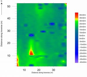
Electrical conductivity is the ability of an object to allow electricity to travel through it. By locating areas of varying electrical conductivity, objects such as wall foundations, middens, dried soils (such as hearths) or moist soils (such as back-filled ditches) can be located.


